- Article published at:
- Article tag: Itinéraires
From the bustling streets of Music Row in Nashville to the soulful rhythms of Beale Street in Memphis, the Cajun culture of Lafayette, the historic appeal of Natchez, the lively atmosphere of Baton Rouge and the vibrant energy of the French Quarter of La New Orleans – this itinerary explores the diverse landscapes, flavors, and stories that define the Deep South.
Day 1: Montreal to Cleveland
Our trip began when we set a goal of reaching Cleveland after the first day on the road. This stop in transit allowed us a seamless transition to the heart of the action on day two.
Day 2: Final stretch to Nashville
Heading south, Nashville awaited us, a city synonymous with country music. By staying at Two Rivers Campground for three nights, we were able to fully immerse ourselves in the rhythm of Music City.
Optional: If time permits, consider a stop at Mammoth Cave National Park to add a touch of nature to the trip.
Day 3: Nashville - A symphony of sounds and images
With only one day in Nashville, we opted for a full city tour to make the most of our time. Boarding an early morning bus, our journey began, offering a glimpse into the soul of Music City.
Our first stop took us to the historic village of Marathon, a haven for creativity and crafts. Dinner at Greenbrier Distillery not only provided a delicious meal, but also the opportunity to savor their exceptional whiskey. Guided tours were available for those intrigued by the distillation process.
Other interesting stops during the guided tour:
Centennial Park and Parthenon: Park featuring the iconic replica of the Parthenon, surrounded by lush landscapes.
Music Row: Visit Studio B, the recording studio where music legends like Elvis Presley and Dolly Parton created their hits.
Belmont Mansion: Step back in time at this antebellum mansion, offering a glimpse into Nashville's history and culture.
What to see in the historic district:
Cumberland Park: A getaway along the Cumberland River, offering picturesque views and recreational activities.
John Seigenthaler Pedestrian Bridge: Cross this iconic bridge for panoramic views of the Nashville skyline.
Riverfront Park: Quiet stroll, with lush greenery and a view of the river.
Tennessee State Capitol: Explore the historic Capitol building, rich in architectural and political significance.
Country Music Hall of Fame: Immerse yourself in country music history with exhibits featuring legendary artists and artifacts.
Printer's Alley: Discover historic Printer's Alley, known for its vibrant nightlife and jazz clubs.
Ryman Auditorium: The legendary place where Johnny Cash first laid eyes on June Carter and discover the cultural epicenter of Nashville.
As evening fell, we ventured down the iconic Honky Tonk Highway on Broadway Street, creating an unforgettable Nashville nightlife experience.
Day 4: Lynchburg – A Whiskey-Infused Day Trip
An hour and a half drive took us to Lynchburg, home of the Jack Daniel's distillery . The visit to the distillery allowed you to discover the know-how behind this world-famous whisky. Lynchburg's small-town charm and quaint town square provide a perfect setting for a leisurely afternoon.
Day 5: Direction Memphis with a stop in Franklin
On your way to Memphis, consider a detour to Franklin, Tennessee. This charming town, with its historic main street and preserved Civil War architecture, offers a brief but captivating stop. Explore landmarks such as the Carnton Manor and the Carter House, providing insight into the city's rich history. Stroll through boutiques, galleries, and enjoy Southern cuisine at local restaurants.
After our stop, we settled into Graceland RV Park in Memphis for three nights, conveniently located near the iconic Graceland grounds.
Note that the campsite is more of a parking lot and is devoid of any nature.
Day 6: Magical Memphis
Our exploration of Memphis began with an in-depth tour of the National Civil Rights Museum at the Lorraine Motel. This powerful tribute to the civil rights movement set the tone for our journey through a city steeped in history and cultural significance.
Beale Street provides a lively contrast to the thoughtful atmosphere of the museum. We traveled this historic thoroughfare, immersing ourselves in the vibrant musical heritage that defines Memphis.
At the end of the afternoon, a surprising detour awaited us at the Old Dominick distillery , where the craft of spirits making took place in the heart of the city. Tasting finely crafted bourbons and whiskeys provided a unique perspective on the diversity of Memphis' cultural offerings.
Day 7: Graceland and a stop at the Mecca of fishermen and hunters
Our visit to Graceland, Elvis Presley's iconic home, gave us a glimpse into the life of the King of Rock'n'Roll. As we wandered through the hallowed halls of Graceland, we were impressed by the opulence and eccentricity that defined Elvis' lifestyle. The audio guide told stories about his rise to fame and the cultural impact he had on the world. Despite the historical significance, the high entrance fees left us wondering if the cost was worth the experience.
Later that day, we visited the Bass Pro Shop at the Memphis Pyramid, America's largest Bass Pro Shop, offering not only an unmatched selection of outdoor products, but also additional attractions such as a bowling, a restaurant and an observation deck.
Day 8: Mississippi Valley Drive towards Louisiana
Heading towards Louisiana we took the road along the Mississippi River for a journey to the heart of American cultural history. The journey offers the opportunity to explore destinations that have shaped the region's history.
Potential stops along the route include:
Clarksdale
Greenville
Lakeport Plantation
Vicksburg
Grand Gulf Military Monuments Park
Frogmore Cotton Plantation, Ferriday
We spent the night at River View RV Park and Resort in Louisiana, a quiet spot along the Mississippi River close to the historic charm of Natchez.
Day 9: Natchez and direction Atchafalaya
We spent the morning visiting Natchez, a city steeped in history that welcomed us with its antebellum homes and picturesque landscapes. A stroll along the Natchez Trace Parkway made for a peaceful getaway.
In the afternoon, we began our drive to Cajun Heritage RV Park , our base camp for exploring the Atchafalaya region for 3 nights.
Day 10: Day trip to the Tabasco trails and Cajun essence of Lafayette
In the morning we headed to Avery Island to visit the Tabasco factory which revealed the secrets of making the famous hot sauce. Our next stop was Avery Island's Jungle Gardens, a natural haven home to bayous, ancient live oaks, and diverse wildlife.
In the afternoon, we transitioned to Lafayette, the heart of Cajun and Acadian culture. A stroll through the historic downtown area reveals charming boutiques and art galleries. Consider visiting the Acadian Cultural Center to learn more about the history of the region. The historic village of Vermilionville, an open-air museum, highlights Acadian, Creole and Native American heritage through interactive exhibits and demonstrations.
Day 11: Baton Rouge Day Trip - History and Elegance Unveiled
Our visit to Baton Rouge proved to be a less enriching experience. Although we enjoyed the grandeur of the Louisiana State Capitol and enjoyed the riverfront, the town had a quieter vibe during our stay.
For those looking for a more interesting visit, consider exploring the USS Kidd Veterans Memorial and Museum or the Louisiana Art & Science Museum. The USS Kidd Veterans Memorial and Museum offers a poignant tribute to American naval history, while the Louisiana Art & Science Museum offers dynamic exhibits and a planetarium.
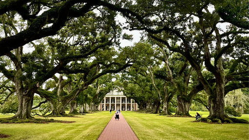
Day 12: Visit the plantations towards New Orleans
We started our route towards New Orleans through the plantations which border the Mississippi between Baton Rouge and New Orleans.
Due to time constraints, we chose to focus on a single plantation, and Oak Alley Plantation became our destination of choice, offering a glimpse into the area's fascinating past.
The route also offered insight into other historic areas. Laura Plantation, Houmas House Plantation and Destrehan Plantation are visible from the road. The picturesque towns of Luling and Boutte, nestled between plantations, seduced us with their local charm which we hope to explore on a future visit.
https://www.explorelouisiana.com/articles/historic-homes-river-road
In the afternoon, we settled in at Bayou Segnette State Park for three nights. Located 25 minutes from New Orleans, it was a great choice to escape the noise of the city at night.
Day 13: Dive into the soul of the French Quarter
Our first day in New Orleans immersed us in the vibrant atmosphere of the French Quarter. We started our morning with a tour of historic Jackson Square, surrounded by iconic landmarks such as St. Louis Cathedral and the Cabildo. A stroll down Royal Street guided us past antique shops, art galleries and hidden courtyards, highlighting the city's unique blend of history and creativity.
During the afternoon, we immersed ourselves in the world of the French market, where the lively mix of food stalls, local crafts and music created a sensory delight. A stroll along the Mississippi River offers a serene contrast, with picturesque views of steamboats navigating the waters.
Our evening in the French Quarter came alive with the sounds of jazz from Preservation Hall. We explored the lively bars of Bourbon Street, each contributing to the city's reputation as a haven of music and festivities.
Day 14: Discovering the cultural gems of New Orleans
Day two began with a tour of the Garden District, known for its opulent homes and tree-lined streets. A leisurely trolley ride along St. Charles Avenue allowed us to soak up the architectural beauty of the neighborhood, with stops at Lafayette Cemetery and Magazine Street for shopping.
In the afternoon, our trip took an exciting turn with a visit to the Sazerac House , a captivating destination delving into the fascinating history of New Orleans cocktails and the iconic Sazerac. Interactive exhibits and tastings offered a unique perspective on the city's lively libations.
As the day progressed, we headed to a local oyster bar for happy hour. The briny goodness of fresh Gulf oysters pairs perfectly with local beers and cocktails, creating a quintessential New Orleans experience.
Day 15: Honey Island Day Trip
A detour to Honey Island allowed us to escape into nature. Opting for Honey Island Swamp Tours , we slid through the swamps, encountered wildlife, and soaked in the lush beauty of the surrounding area.
Day 15-20: Coastal Serenity in Pensacola
Our trip took an unexpected turn when a storm disrupted our plans in Pensacola, closing Fort Pickens Campground and forcing us to miss the final leg of our trip. However, had the weather been in our favor, our planned exploration of Pensacola would have played out as a gripping final chapter.
Our itinerary included a visit to the Pensacola Lighthouse and Historical Museum, where panoramic views of the Gulf Coast awaited atop the iconic structure. A stroll through the charming historic village of Pensacola, with its well-preserved architecture and cobblestone streets, was also on the agenda.
We envisioned immersing ourselves in the local culture, perhaps sampling seafood delights at one of the waterfront restaurants or enjoying a leisurely stroll along picturesque Pensacola Beach. Alas, nature had its plans and our adventure in Pensacola remained a tale of what could have been. As we redirected our trip elsewhere, we carried with us the anticipation of one day returning to experience the charm, history, and coastal beauty that Pensacola promised under sunnier skies.
Learn More